The weather across the UK looks unsettled for the Coronation weekend, said the Met Office today.
The meteorological service has predicted that there will be showers or longer spells of rain for many and some heavy, thundery downpours are expected on Friday and Sunday.
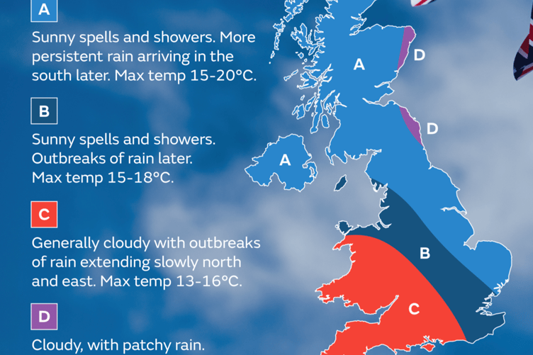
Through Wednesday there will be hazy sunshine across much of the UK, though outbreaks of rain will affect the west of Scotland for a time before brightening up later on. Gusts of 40-50mph are possible across parts of southwest England.
Thursday will be a more unsettled day, with an area of low pressure bringing some wet and windy weather which will move north eastwards across the UK. Most areas will be cloudy through the day, and it is most likely to stay dry through the day in the north and east. Temperatures will be capped at 16°C for many under the cloud, though in any sunny spells in the south it could reach 20°C.


Friday will be a day of sunshine and showers, which could be heavy and slow moving at times with some thunder, lightning and hail. The showers will affect most parts of the UK. Highs of 19°C are once again possible in the south of England.
Currently Saturday is forecast to be another wet day, though with generally less intense rainfall compared to Friday.
Met Office Deputy Chief Forecaster, Steven Keates, said: 'On Saturday we will see some heavy rain moving into the southwest in the early hours which will move north eastwards through the morning. This is likely to bring some rain to London by around lunchtime as it spreads east and north across roughly the southern third of the UK.'
With celebrations continuing through the Bank Holiday, Sunday will see areas of rain breaking up into heavy, possibly thundery showers for many parts of central, eastern and southern England. The driest and brightest weather looks set for western parts of the UK in Northern Ireland, Wales, western Scotland and southwest England.
Monday will see another band of rain move east across the UK, followed by sunshine and showers, although there are currently some uncertainties in the timing of this. Further ahead there are signals for higher pressure to become more dominant by later next week bringing a more settled spell.
Comments
This article has no comments yet. Be the first to leave a comment.